
ENGINEERING AND CONSULTANCY
SAMPAŞ has adopted the principle of creating civilized and high quality of life brand cities by working in cooperation with our municipalities in Turkey's urban transformation process.
Feasibility and Most Effective and Efficient Use Value Analysis
The most effective and efficient utilization of the transformation of risky areas located within the borders of metropolitan, provincial and district administrative areas;

* It is aimed to conduct the necessary research, study and reporting for a legally permitted, financially feasible, physically feasible, maximum efficient use.
- Analysis of the whole city (economic, social and spatial structure indicators)
- Spatial overview of the project area (current situation analysis, project area and nearby indicators, real estate market analysis, planning approaches)
- Spatial development scenarios (swot analysis, planning, urban design)
- Transformation scenarios and feasibility (transformation scenario, project costs, project revenues)
Building Hazard Scoring System
Earthquake Hazard Scoring System can be applied on city scale or building basis. In accordance with Law No. 6306, it is carried out with scientific and technical measures, in a low-cost and fast manner, using geographical information systems, and approved by the university.

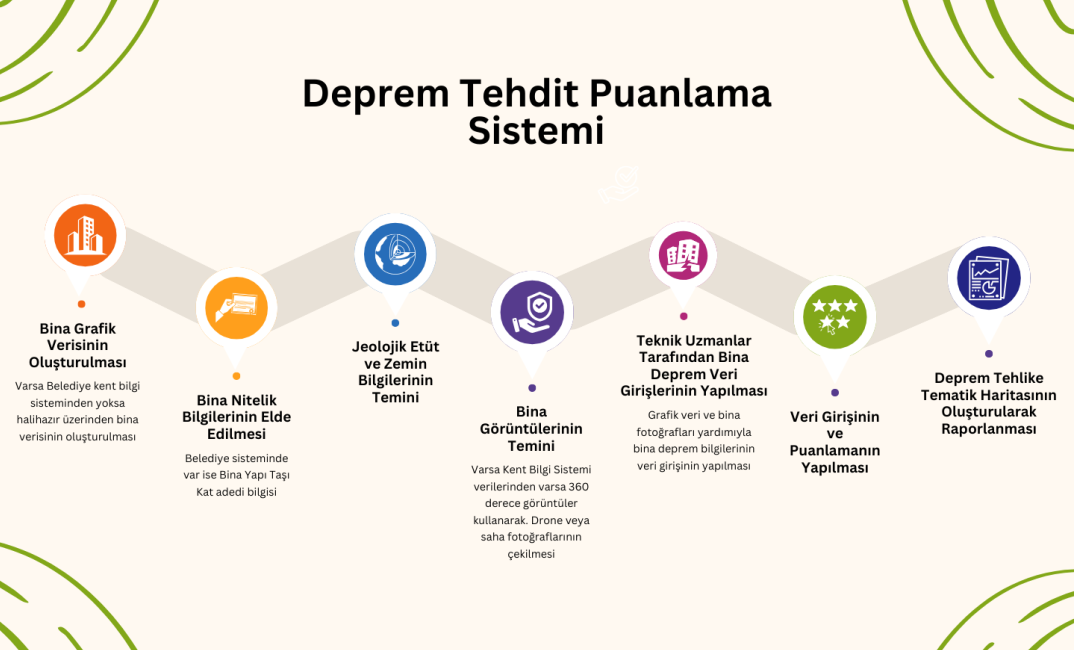
With a new fast, affordable and reliable scanning method;
- Conducting rapid scans of existing buildings and risk classification of the regions,
- Development of a scoring system that allows for rapid, economical and reliable identification of the distinction between buildings with and without imminent risk,
- Identification of areas to be prioritized in determining urban transformation strategies,
- It is also possible to determine the risk status of high-rise buildings (>8 storeys) in a fast, economical and reliable way, which was not possible in previous methods.


Urban Transformation Strategy Document
It is aimed to identify potential risky areas located within the borders of metropolitan, provincial and district metropolitan areas in order to solve problems such as illegal constructions, risk of natural disasters and social explosions, and to report possible solutions to be implemented in these areas.

- Analysis of the whole city and collection of data (physical environmental studies and spatial analysis, infrastructure analysis, real estate sector analysis, socio-economic impact analysis and synthesis)
- Prioritization of transformation areas (strategies, identification of project areas)
- Determining the legal basis (determining the most appropriate legal framework for project implementation)
- Determination of financing management (pre-feasibility study and needs program)
- Establishment of urban transformation implementation schedule (implementation action plan)
- Determination of design principles (urban design guide)
Urban Transformation Management in Cities with Digital Twin
In order to create healthy and safe living environments in accordance with the norms and standards in areas under disaster risk and in lands and lands where risky structures outside these areas are located, it was aimed to transform Disaster Risk Areas with Law No. 6306 in 2012. As of 2019, the Ministry of Environment, Urbanization and Climate Change requested the preparation of the Urban Transformation Strategy Document in all metropolitan, provinces and districts, and the cities started to prepare the Strategy Document. A technological infrastructure is required for the management of the prepared document and related decisions. In order to ensure that urban transformation is managed in a sustainable and holistic manner, an infrastructure has been created through the Digital Twin Platform created by Sampaş Holding Smart Cities to manage the urban transformation strategies of cities.

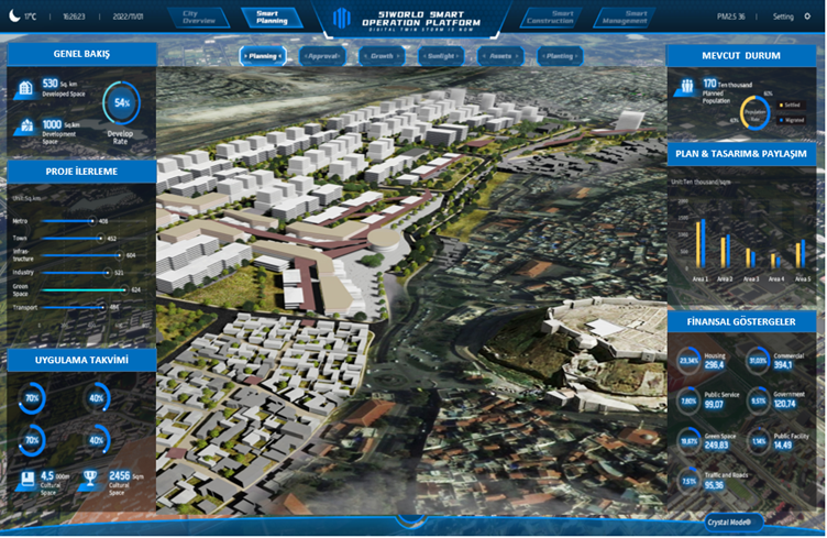

- Monitoring of Reserve Areas, Risky Areas and Risky Buildings
- Current Situation Information
- Displaying the socio-demographic surveys conducted in the Reserve Area, Risky Area
- Plan, Urban Design information and Digital Twin to visualize both pre-plan and post-plan situations and the impact of the design on the city
- Reserve areas, financial indicators of risky areas
- Following the implementation schedule
management of the urban regeneration strategy document is provided.


